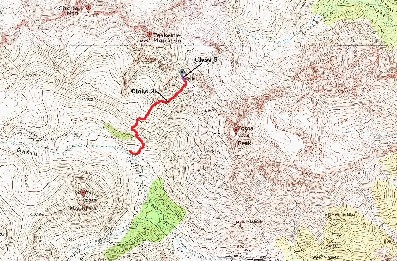
“Coffeepot” 13,529’
East Chimney (via Yankee Boy Basin)- Class 5.2
Trailhead- Bathrooms up Yankee Boy Basin
2.48 Miles | 2,209’ gain
Starting elevation- 11,380’ | Ending elevation- 13,529’
Kiefer Thomas, Regina Thomas
“Coffeepot” (9.9.2021)
We arrived at the Yankee Boy outhouse around 7:30 am. It was cold enough that gloves and a hat were warranted. But during the serotinal part of summer, one needs to start packing more clothing. It’s been a hot minute since I’ve used it (the outhouse), and embarrassingly, I didn’t know how this new, space-age toilet worked. I stared at it, pushed the pedal down like you do on the narrow-gauge train but nothing happened. I was perplexed. I didn’t want to leave all that concentrated evil for the next unsuspecting hiker, that’s just plain wrong. I stepped down on the pedal a few times thinking the trapdoor was stuck and then I saw movement. I started to laugh at myself.
“Kiefer, you’re a dumbass!” still laughing.
“Hey Regina. You need to come in here and see this thing! It’s so cool!” I said, not sure if that sounded genuine or devious.
“Yeah, there’s one just like it up Nellie Creek.” She said distractingly. Regina was finishing up adjusting her pack. I walked back over to the Jeep, threw my pack on and started off crossing the road towards the social trail.
Last time I came up here, I hiked half-way up the slope building some cairns to speed the ascent for a soon-to-be trip, but that jaunt never happened. As we were hiking up the slope which, even near the bottom doesn’t fool around, all the cairns I built were gone. It was a little irritating but I just chalked it up to other hikers knocking them over and weather; so be it.
Teakettle and “Coffeepot” were on the agenda for the day and if time allowed for it, Potosi Peak. But due to the ‘Slope of Suck’ being far worse than I remembered it, we lost a lot of time on the ascent. The slope really kicked Regina's butt. So we ended up climbing only “Coffeepot.”
For those unfamiliar with this slope, if you go, be prepared for 3,552’ elevation gain in 1.24 miles to gain the ridge. That comes out to around a 28.5% grade. So bring your iPod and kick out the EDM.
This would be Regina’s first technical peak. The goal was initially Teakettle but once we attained the ridge, we decided to do only “Coffeepot” and then mosey on over towards Potosi.
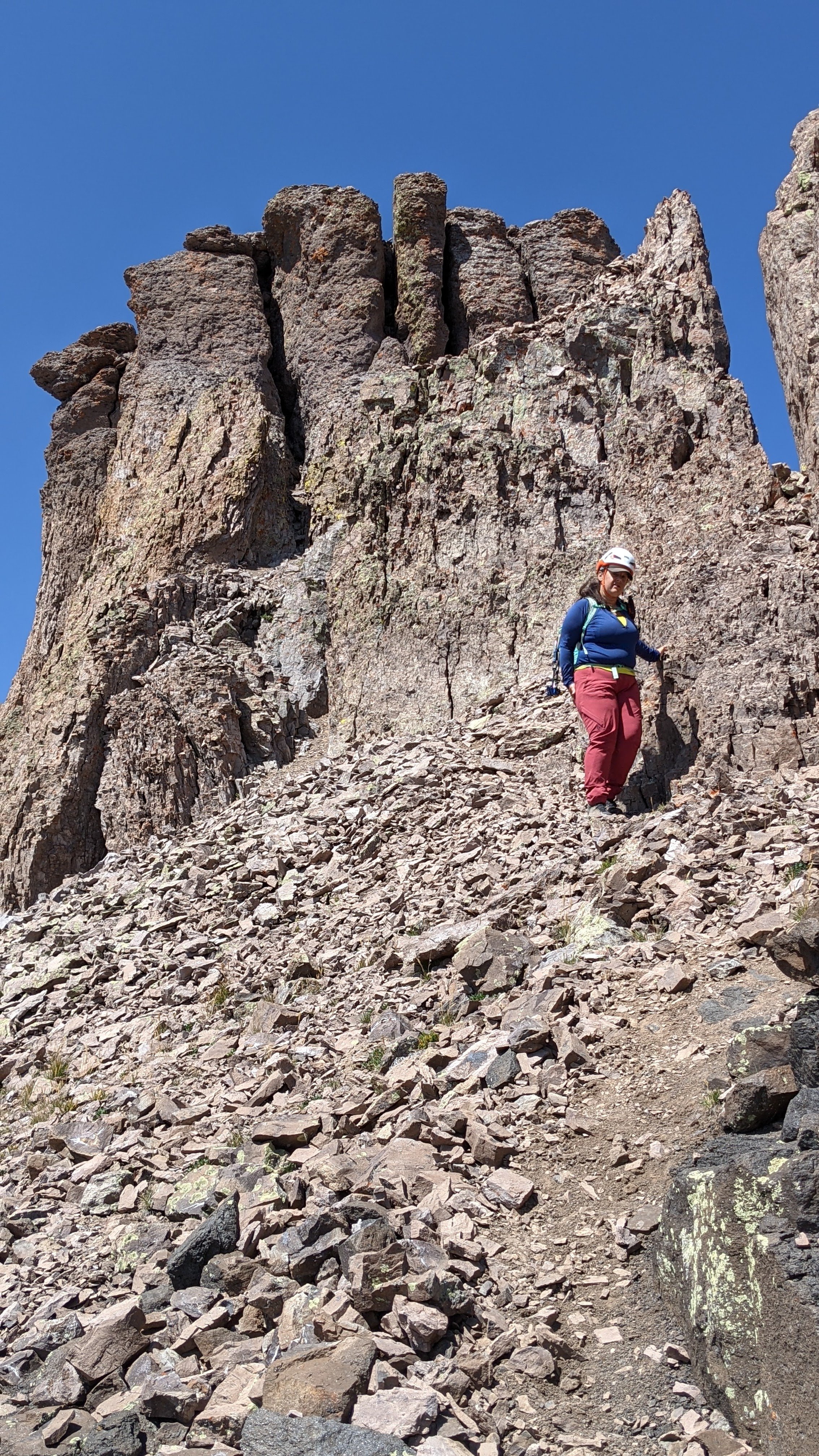
We scrambled up the short pitch to the base of the chimney and geared up. There’s not a whole lot of room on this tilted alcove so choose carefully where you put your pack.

Looking up at the chimney
Regina descending from our climb

Looking up at Regina still on the summit after I rappelled down

Regina roping up
The chimney is virtually unprotectable. I brought a couple small pieces to ‘try’ and place but more for Reginas benefit of having to excise them from the rock and see how it’s done, understanding placement. In 35’ of wiggling, I found one spot that accepted a .4 friend and it took me a bit to plug it. Even I was surprised. But none-the-less, it would serve its purpose.
I wiggled up past the light constriction and reached the top lip. I then moved slightly out of the chimney and pushed out on my feet (opposite wall) to mantle over the lip onto the summit. It’s an easy move if not a tad awkward.
I anchored into a couple of rap rings & equalized it with a second girth attached to two of the runners and butterflied it to a locker on my harness. It was way overkill, but I wanted to be able to peer over the lip down at Regina and offer instruction and guidance if necessary.
I kept the rope on her taught as she was very nervous. She moved slowly & methodically (as we all do our first time) trying to get used to this type of climbing. We go to the Rotary Park in Ouray all the time to climb (they’re all sport routes) but the routes there consist mostly of slick, downward holds, very different from a shallow volcanic chimney, harder IMO.
She powered through the slight constriction and was soon enough reaching over the lip for the edge. She sat on the summit and we both enjoyed the views. She took a few minutes to calm down. I hugged her, “Pretty different from a gym, eh?” I laughed and she soon did to, quelling her nervousness. I left a register and broke out my summit beer, a PBR Hard Coffee. Not my kind of drink, but fitting I thought, for “Coffeepot.”
I brought my short rope for the day (32m, 8.8mm) since any rappels would be short. I left a 4’ piece of purple webbing to back up the existing webbing. I tied in and descended back to the small alcove like a raindrop on a metal gutter. I pulled the rope, rethreaded it and lowered Regina back down safely. We packed up, chatted with a couple coming back from Potosi (they didn’t summit, not sure why) and steeled ourselves for what would be a descent that would try my nerves.

Potosi Peak- 13,793'
This section is the real reason for the report.
It’s not that Potosi Peak is a hard objective even though we didn’t summit, all that loose rock is frustrating to be sure. But for those who have already been up there, two things are evident. A.) The sheer instability and looseness of the rock is actually a facet to be reckoned with. Among reputations that certain areas of the San Juans have concerning rock quality, this ridge holds court over its own circle of hell. And B.) Escape from Potosi, Teakettle and Co. is difficult without having to retrace ones steps.
Regina had a trip report from Alex and Kristi Henes that spoke of a descent route off of Potosi without having to retrace up the crap ridge back to “Coffeepot.” Their route took them down through the ‘Cliffs of Babel’ (my nomenclature) that avoided the horrendous cliffs and deposited them on Yankee Boy Road only a few hundred feet below the outhouse. I believe Otina and Ryan Richardson (RyGuy) also descended this route as well. I was intrigued! So I let Regina guide the way since she had the beta. Coming off Potosi, this descent route is INVALUABLE.
Once we hit the saddle, we called it a day. Our pace was just too slow. The rocks were taking a toll on Regina. We decided instead, to come back and do it as a spring snow climb, maybe grabbing the North Couloir in the process.
From the top of the ridge, follow the faint climbers path east towards Potosi. We followed this to the saddle. There are a couple of short downclimbs that from above, don’t look like they’ll go, they do. Take heed on these two short sections. There’s ample opportunity for an accident. So be careful.
From the saddle, there are a few rock gendarmes & towers below you about 120 meters. There are two gullies that break through these gendarmes that do not cliff out. Keep an eye out for these as you descend the upper ridge. They’re more noticeable from high. Head for the eastern most of the two gullies. They both work, but the western one is harder to see and contains smaller rock. Plus, it’ll take you slightly out of the way.
We descended the eastern gully one at a time to avoid knocking rocks down on one another. Most of this is probably on a 32°-35° slope with rocks varying in size from a volleyball to a large printer. The descent past the gendarmes is fairly straight-forward. Past the gendarmes/towers, the slope opens up dramatically and is huge. In fact, the slope above these towers to the ridge could fit 5 times over on the lower ramparts.
As you descend, start to angle climbers left towards a huge grassy patch of tundra. DO NOT descend straight down, it cliffs out.
As you traverse left, descend into and cross a shallow gully. However, before you drop down into this gully, look for a faint game trail on the other side. You might have to scrutinize the other side to see it since the slope is a patchwork of tufts of tundra, grass, clumps of dirt and rock. Mark the spot and ascend out of the gully for this trail. It’s not necessary to hit this trail, but due to the steepness of the slope, it’ll make life easier.

Close Up view of the Cliffs

Descent Route

Southern slopes from the "Coffeepot" / Potosi Peak saddle

Stony Mountain- 12,698'

Summit Selfie

Looking down onto Yankee Boy Road from the ridge
I descended the gully for a bit and from up top, it does look like it’ll go, it doesn’t. It dramatically steepens and falls over the edge of a cliff. Even in late summer, there is some water in this gully as several springs percolate out of the ground into it.
The game trail will eventually evaporate into the slope above the grassy patch. Leave the trail and head straight downhill onto the grassy patch. It’s still steep but it’s all dirt. As before, do not continue straight down to the edge or veer off to the right, it cliffs out. Instead, angle slightly left. There is a small rock fin called, ‘The Shark’s Fin.’ This is the key to getting through the cliffs.
Once you reach the Fin, getting into the lower gully is tricky. But there are two options to do this:
Downclimb directly from the fin into the gully on highly fractured class-3 rock. It’s only about 15’-20’ or so but it’s a delicate downclimb. The top of the gully proper is exceedingly loose until you descend another 20’. Then things calm down a bit.
Or, walk down to the right wrapping around & descending about 20’ following the edge. Enter the gully here on a small 2+ ledge covered in scree. The ledge becomes downward sloping and might entail a bit of a jump to get into the gully. But it’s only a few feet. Do not descend straight down into the gully from the ledge. Access is blocked by a steep 30’ solid dihedral.
When in the gully, the slope will dramatically ease up in pitch. It stays loose but at this point, everything is manageable. Keep descending but stay to the center. The sides of this slope is scree covered slabs. The center is mostly dirt.
At the bottom of the slope, one can descend through the trees and vegetation (a bit of a drop) or stay left and descend a runout gully. This will wrap around the ‘tree mini-cliff’ back to the right. From here, just follow the runout back to the road, a few hundred feet below the outhouse.
I hit the road and let out a cathartic sigh. I mean, I’ve had my moments on loose rock and the majority of the time, it doesn’t bother me. I view loose rock as kind of a ‘Price of Admission’ to a lot of peaks, it is what it is. But this ridge and descent really tried my nerves. Of course, I’ll be back. But better mentally prepared next time.