Ulysses S. Grant Peak (13,778’) and “V2” (13,319’)
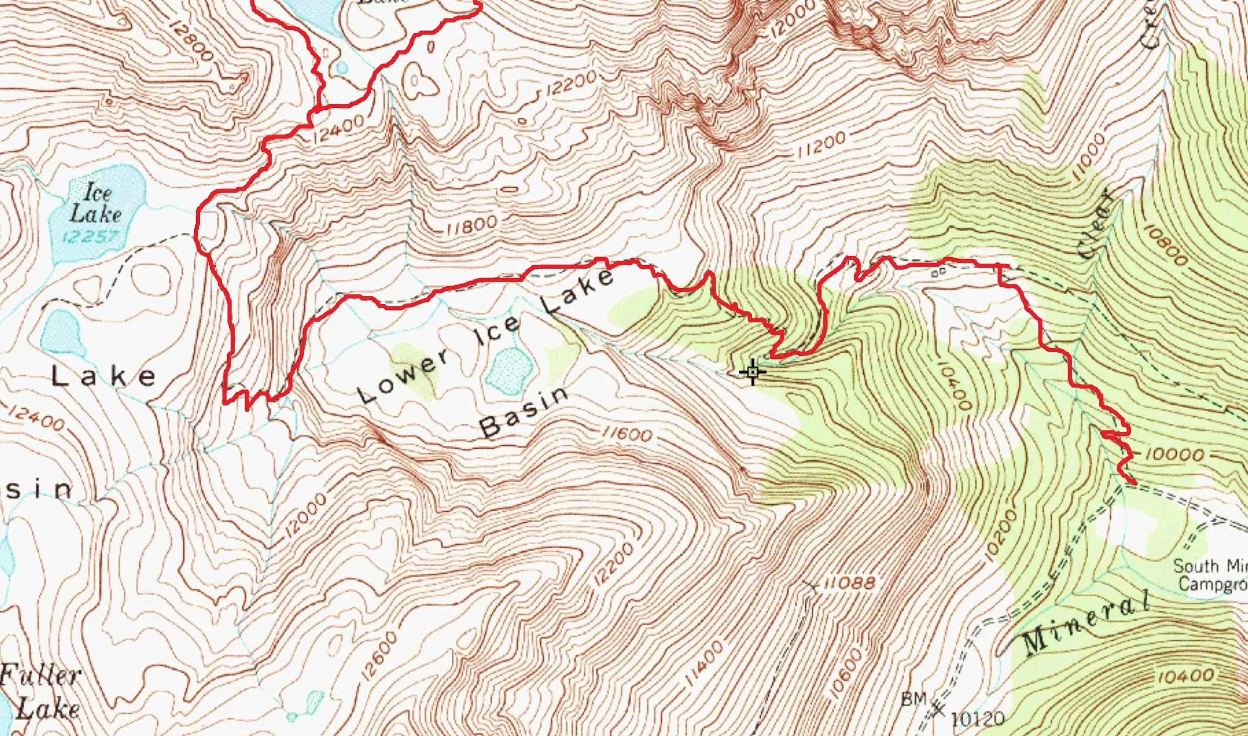
South Ridge - East Ridge (via Island Lake)- Class 2
Trailhead- Ice Lakes Trailhead
6.67 Miles | 4,347’ gain
Starting elevation- 9,840’ | Ending elevation- 13,778’
Kiefer & Regina Thomas
Trekking into Ice lakes Basin in the throes of tourist season can be a risky proposition. Much like hiking Mt. Bierstadt on a Saturday afternoon in August, the way is an obstacle course fraught with peril and hazards. All manner of risks can be encountered on the trail ranging from: running into very thoughtful people audibly sharing their Toby Keith, Taylor Swift or Kanye to unsuspecting fellow hikers to being peppered with relentless questions such as, “How much further is it?” to ducking those little, Skittle-blue, poo-bags neatly tied shut like landmines. But I assure you, they are NOT Skittles; unless you’re another dog, then perhaps. Indeed, the trail is a dangerous place not for the faint-hearted.
We left the trailhead (Clear Lake Turnout- that's MY TURNOUT, so DON'T use it) at the staggeringly awful and early hour of 6:30 am to hedge our bets in not seeing anyone. However, running into the homestretch of ‘off-season’ or as some locals call it, ‘mud-season,’ Regina and I were able to speed up Ice Lakes Trail relatively unharried and unobscured. Upon reaching the upper basin, we wasted no time in dawdling around at the lake.

Although the views of Golden Horn, Fuller and Vermilion are always spectacular and never fail to impress. We immediately banked sharp right and cut across the tundra following the frayed filament of a social trail. We skipped across the outlet stream like a couple of skipped stones and hit the Island Lake Trail at a half gallop. We ascended to the old site of the Golden Gate Mine (12,188’), sped up the shoulder and out of view without ever being noticed.
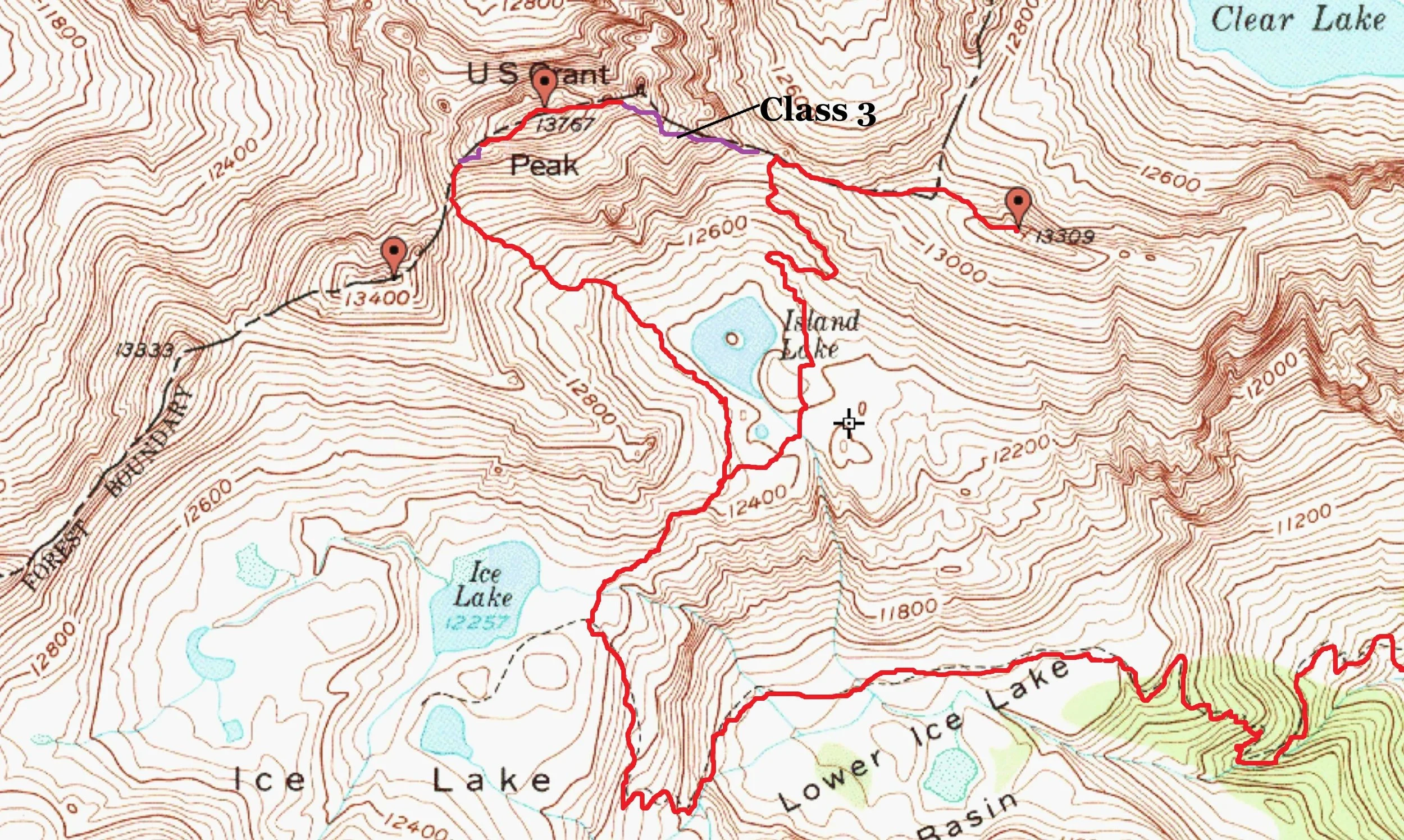
Full disclosure here, I have a problem with Ulysses S. Grant Peak. I have a problem with its name. And no, I am not a Stonewall, Davis or Confederacy sympathizer. Fact, I admire the man for his military and field acumen, especially for what he did at the bloody battle of Vicksburg. But when compared to everything else in Ice lakes and Island Lake Basins, the mountains name is just so random. Many of the peaks in the locale are either named after the old 15-minute quadrangles (Telluride, Sneffels, Vermilion) or after people associated with the San Juan Mountaineers. But Grant is an outlier. After much searching and yielding almost no answers, all I could come up with is that A.) US Grant was first climbed in 1932 by Mike Walters and a small CMC group (Jeff Golden, can you verify this?) and that B.) once the Civil War ended in 1865 and the reconstruction began, many soldiers headed west in pursuit of a new life escaping the memories, guilt and abject death that rained down upon everyone in the eastern states. I’m assuming some of these lost souls, many now without families were employed by private mining companies in the Ice lakes, Mineral and Silverton mining districts, had laid eyes on this particular mountain and saw it fitting to name it after a respected general and man who would later, come to be the United States’ 18th president.

Regina climbing up the short headwall on US Grant Peak

A better capture of the whole headwall / notch on US Grant Peak

The saddle between US Grant Peak and "V4"

Looking over at "V4" (13,541')
The approach to the saddle of US Grant and V4 (13,540’) is fairly straight forward. The trail eventually peters out into grassy tundra suffering from alopecia which, in turn, gives way to the obstinacy of that delightful San Juan scree and rock we all know so much. The closer to the saddle we got, most of the talus turned into hardpan dirt, probably my least favorite terrain to be on.
We took a small break at the saddle to layer up as the winds were making things a bit cold for just a T-shirt. The skies out west were thick with smoke but oddly, didn’t seem to navigate any further east than where they already were. I thought for sure in a couple hours time, that we would be choking inside a smoke bank. Thankfully, that never happened.
From the saddle, V4 is easy pickings. It’s basically a loose 3rd class scramble, short at that. However, considering we were planning on descending Grant’s East Ridge (one of the worst routes I’ve ever done), I wanted the extra time for route finding & necessary exploration since there is approximately 2.61895% information out there on it.
Leaving the saddle, the Southwest Ridge on Grant is relatively short. The lower half of the ridge is easy to follow, a bit loose (but nothing too crazy) and cairned more than I expected. The whole of the ridge is basically split into two sections. The 4th class cliff does the splintering. I’ve read plenty of descriptions and accounts of this ‘famous’ cliff labeling it everything from 3rd class to 5-easy. On ratings, I didn’t think the rock was that bad or loose, nothing like, say, what’s found on Teakettle, Dallas or Mears Peak. But I also ‘cut my teeth’ in the beginning as I was learning mountaineering in the Elks. So that has to be taken into consideration. That being said, ratings can only be trusted if there’s a large enough sample size of experience judging the routes single hardest move. The weighted average trumps (sorry, bad word), the weighted average surpasses any one singular opinion because experience in and of itself, can be a huge outlier. But it is in my 100% factual opinion, that this move is 4th class.
After Regina and I cleared the crux, we traversed right on a cool ledge wide enough to pedal a red, Radio Flyer Tricycle across. And it was here, that the rock took on a wholly different character, reminiscent of what can be found on Trico Peak, T10 or to a lesser extent, Pilot Knob.
We scrambled up shallow gullies and low-angle bulges on light gray, flaky volcanic rock. Pieces would easily come off in your grasp but the whole of the rock would stay put, a bit of an odd pairing, like Mike Pence and Alistair Crowley.
After no more than a few minutes of this rather enjoyable scrambling, we arrived at the summit very satisfied. I thought Ulysses S. Grant was one of the finer summits in the whole of Ice Lakes Basin.

On the summit of US Grant Peak

My climbing helmet as we rest on the ridge leading up to "V2"

"V2" as viewed from the lower East Ridge on US Grant.
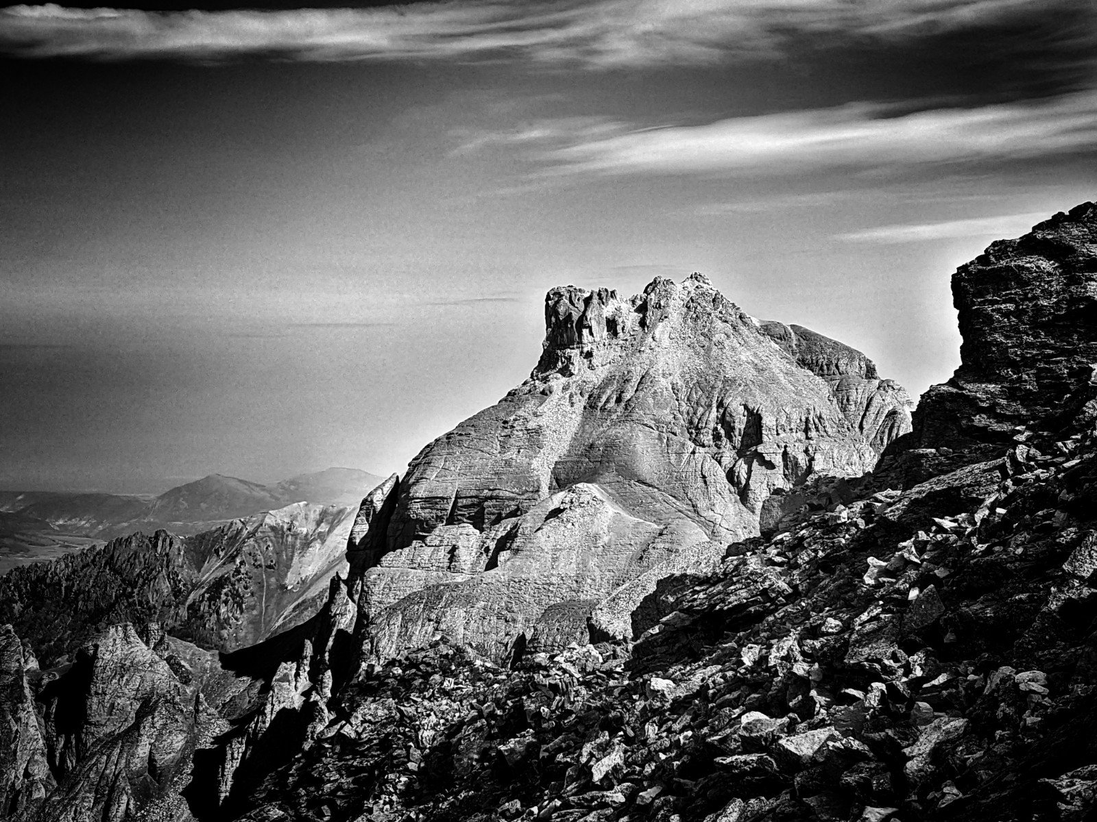
"V3" (13,545')
Descent: This is where things get interesting. Grant’s East Ridge is the Edward Hyde to the Southwest Ridges’ Henry Jekyl. The mountain as a whole isn’t the worst for loose and dangerous rock. In fact, when compared to other peaks in the San Juan Mountains, it’s not bad. But the East Ridge is another beast entirely. Nothing about it was remotely enjoyable or safe. The only thing I can say that I liked about it, was that it was uncharted territory. And in Colorado, ascending or descending a face or ridge that few people have done or that little to no information is available, should be viewed as a reward. Most places in Colorado have been sliced, diced, vivisected and given their own Facebook page or chapters in some Falcon or CMC guidebook at this point. Despite the quality of the route, in hindsight, I’m happy to have scrambled something that I had no knowledge of, damn the results.
We left the summit descending a loose patchwork of ledges switch-backing to where it was easiest taking our time. I stopped frequently studying the slope to make sure certain paths would go and that we weren’t cliffing ourselves out. We initially stuck to the crest and larger cropping of ‘solid’ rock, hugging anything that looked substantial or firm. But even then, we would end up inadvertently ripping pieces out. Sometimes only a fragment would come loose, sometimes the whole piece came out. So the question became, do we stay on the crest and traverse these smaller cliffs risking injury or do we delve down into the even looser gullies knowing full well what to expect with no surprises? We chose to rock ski and butt slide the gullies.
Another factor in deciding to use the gullies…was height. At 6’0” feet tall, I have height to my advantage in climbing anything and reaching for holds. For those of a more shorter stature, like Regina, lacking that extra height and ability to reach can and does compound difficulties. It also increases a routes difficulty grade. And on already untrustworthy rock, we figured the gullies, even though time-consuming would be a much safer option.

Our descent route down the Eastern Ridge on Grant.

Ulysses S. Grant Peak from Island Lake

Summit selfie on "V2"

Celebratory beers at Avalanche Brewing in Silverton