A Monumental Ridge Run…
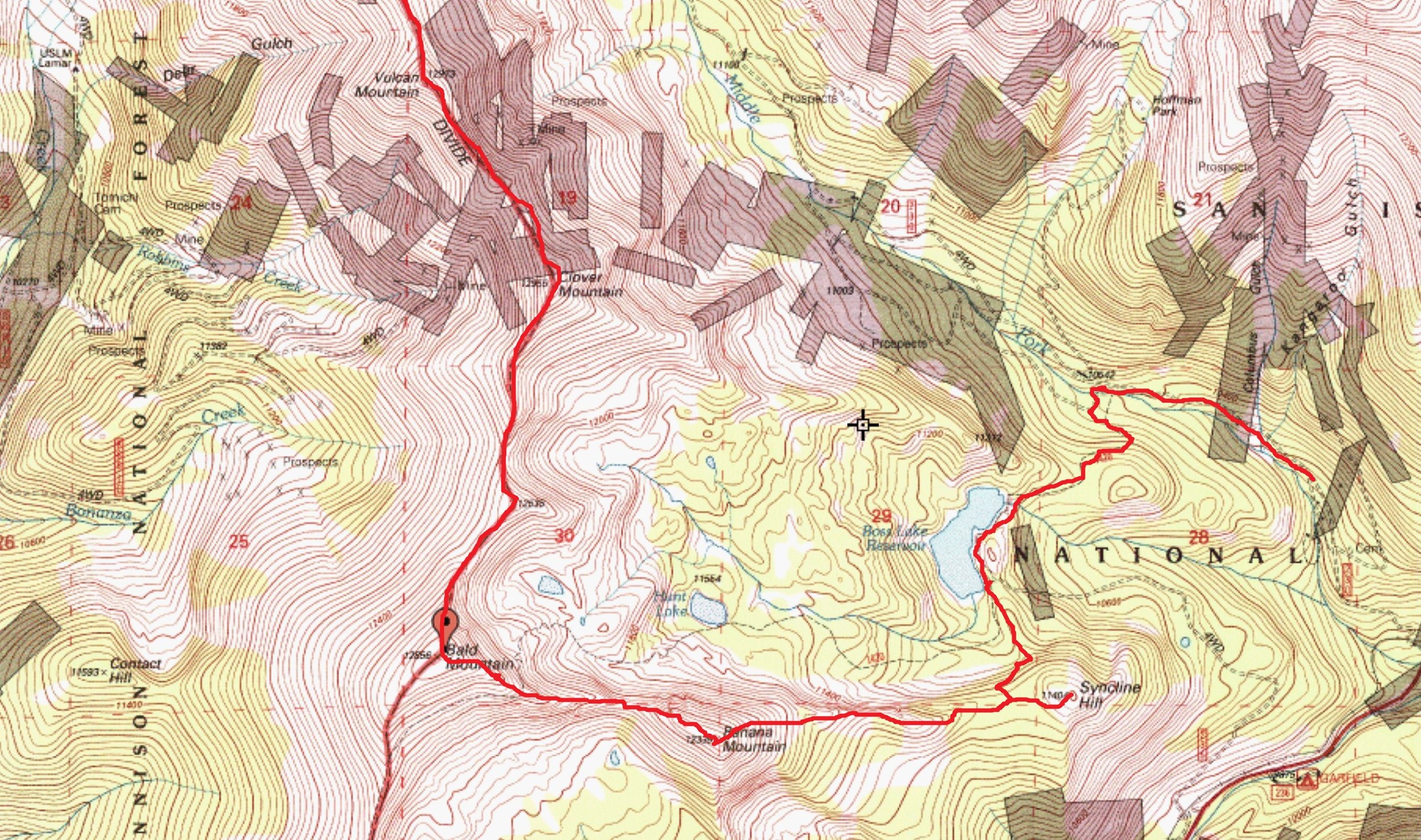
13.14 miles & 6,285' of gain | Class 2 | Start: Lower Boss Lake TH (10,480’) | Finish: Alpine Tunnel TH (11,160’)
September 9th, 2023
There is a ridge I have wanted to scale for quite some time. But due to the sheer amount of other options that Colorado has to offer, this ridge has often taken a backseat.
With a free & clear weekend coming up, Regina and I tooled around Salida on Friday and then stayed at the Monarch Mountain Lodge that night (originally built in 1963). On a side note, as much as I like the lodge and staying there, walking those hallways late at night feels like you’re in the Overlook Hotel from The Shining. It’s not so much a creep vibe as it is an old, antiquated vibe where you can almost feel the memories emanating from the walls like heat.
The plan was to have Regina drop me off at the Boss Lake Trailhead. Then I’d amble up to my first objective, Syncline Hill and southwest towards Bald Mountain. Then I’d cruise the ridge north towards Hancock Peak, down to Hancock Pass and out via the rough 4x4 road to the old town site of Hancock where Regina would be waiting. And for the most part, that’s exactly how things turned out.
I left the lower Boss Lake Trailhead (well, .3 mile up the road anyway) at 6:45 am. Since there was weather moving in on Sunday, a decent cold front promising moisture, I wanted to get as much of the ridge done before the stormy harbingers showed up. And honestly, I should have left earlier. But after a bad night of sleep (the room was too warm & noise from hwy. 50), I couldn’t rouse myself at 5:00 am with the alarm.
I made great time up the road to the turnoff for Boss Reservoir. From there, it was still gravy as I had the CT to follow to the south end of the lake. Of all the times I’d been up the Middle Fork, I’ve never hiked to Boss Lake. The small basin was beautiful! Plus, the cool air was making the fresh, damp Earth linger up into the air. I lounged on the dam for longer than I should have. But the moment was just too good to pass up. And to have it all to myself, well, what’s not to love about that?
Once I left the CT/CDT, the bushwhacking south up to the ridge wasn’t terrible, something I was grateful for. I even made a short detour to see if I could stumble across the old bones of the Ben Bolts Paymaster Silver Mine (I couldn’t find it). I made the summit of Syncline Hill at 8:10 am at right around three miles. It was an incredible little perch being able to see highway 50 being born in the flats of the lower Arkansas Valley then weave its way up Monarch Pass like a piece of discarded thread. I left a summit register, built up an ancient cairn and steeled myself for what was ahead of me…eight more peaks and roughly twelve alpine miles.

Looking back at Bald Mountain from the CT/CDT.

Looking back at Banana Mountain from the Eastern Ridge on Bald Mountain. Salida is out there in the valley.

The lower eastern ridge leading over to Bald Mountain

Road junction to Boss Lake Reservoir/#230 and the CT (Colorado Trail)

A short segment along the CT/CDT while heading over to Clover Mountain

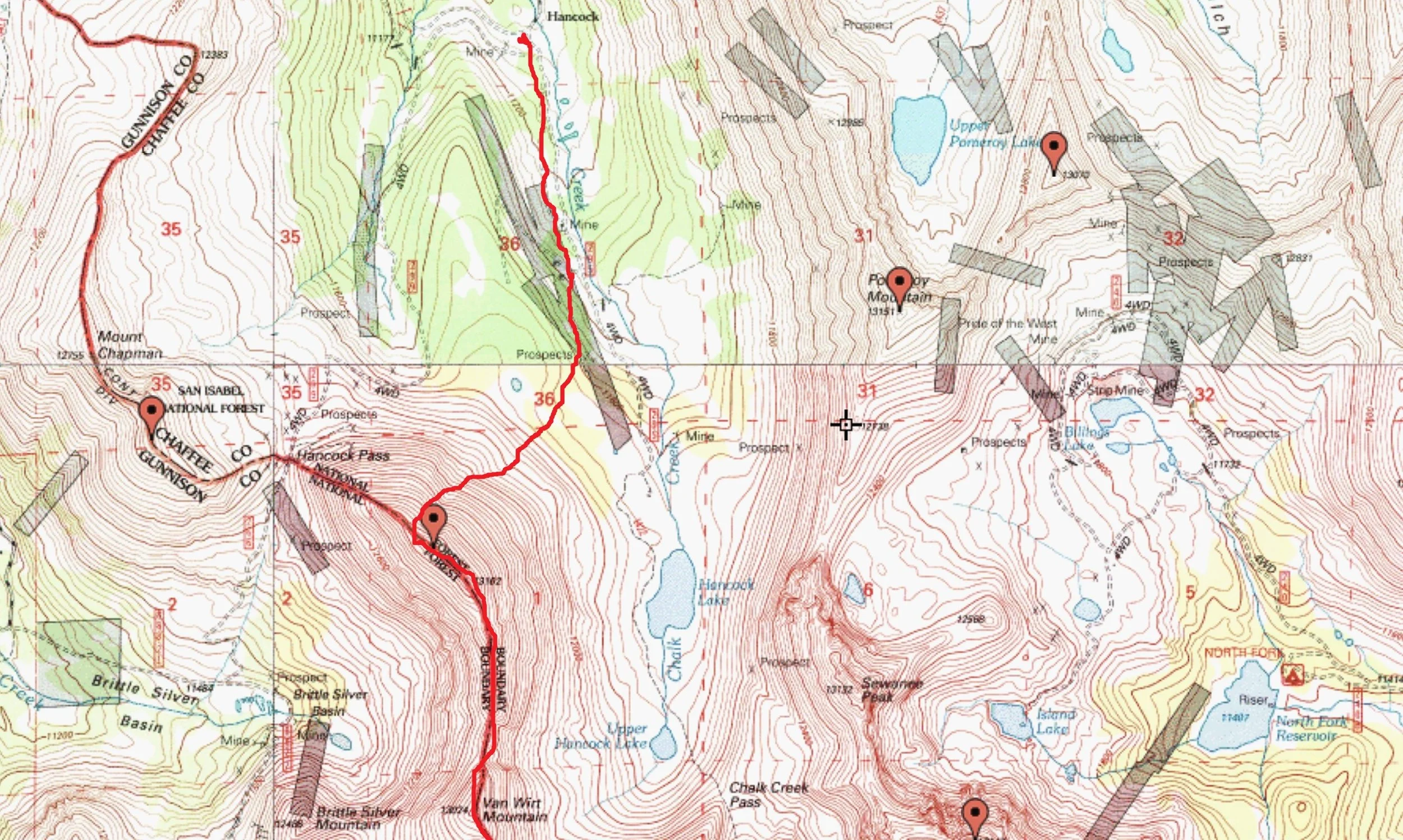
Looking down onto Hancock Lake from near "Van Wirt" Mountain. Looking west.

Hancock Pass
I really love ridges. Because most of the time, they take the guesswork out of route-finding, and this one was no different. I cruised across the forested ridge kind of stuck in my own head thinking about some problems at work.
Something else you’ll find in the forest is grouse; and these bastards are like ptarmigan. You generally won’t see them until it’s too late. If you get too close, they launch into the trees like a combination of a hand grenade explosion and a helicopter. And once this particular bastard took flight, of course I didn’t see it, I did manage to yell a few expletives and scream like an eight-year-old girl. I cursed the damn bird in between laughs as I made my way towards Banana Mountain. Then I reminded myself, if no one was there to witness it, did it happen? My man-card is still safe in my wallet!
The ridge up to the summit of Banana was fairly boring. It was your typical alpine rock, scrub tree terrain. I’ve attempted Aetna twice in the winter and once as a successful spring summit. And all three times, I’ve looked at this very unassuming peak thinking to myself, I bet the views of Aetna would be marvelous from there. Well, the views of Aetna & Taylor were pretty terrific. The summit was a small ordeal with two small rock mounds and no cairn. The views of Waterdog Lakes to the south were quite nice though. Speaking of which, the Waterdog Lakes are named because of a small population of Tiger Salamanders that live in the waters. Regina had also decided to take a quick hike up to the lakes, but the dog didn’t let her near the water, so I don’t know if there are any salamanders still.
The intriguing thing (at least to me) about this low, forgettable 12er is its name. After spending a couple days researching dead-ends on its etymology, all I can come up with is an educated guess; that this very oddly named mountain was christened so because of the warmer than normal temperatures the lower Arkansas Valley usually receives in the winter. Since the very productive and valuable Madonna Mine was located in the hills above the encampment of Monarch, ‘Banana Mountain’ would have been part of the immediate skyline. The turn of phrase, ‘Banana Belt’ has been around for a long time. So perhaps the miners started referring to this mountain as Banana because of the warm winter temperatures they experienced. I don’t know, but I think it could stand to reason.
I left the summit (my shortest stay of the day at 5 minutes) and started the traverse wrapping north towards Bald Mountain. The elevation loss (only a couple hundred feet) wasn’t bad, but at least from the summit of Bald, the initial elevation gain from the road, only another 700’ would be done.
The summit of Bald was a huge and flat affair. You could play a game of football up there! The CT/CDT wraps around the summit on the west side (the topo map on Lists of John shows the CT on the east side) and catches the south ridge again around 12,200’. As ‘original’ as some naming conventions are (Sheep, Bald, Bear, Round) this one is actually deserved.

Boss Lake Reservoir in the early morning…
The ridge traverse over to Clover Mountain is about 1.3 miles. It’s all class-2 with some class-1 as I wandered up the CT for a short stretch. This was the only time that I encountered anything resembling a trail, developed or otherwise. 98% of this traverse is either tundra or easy choss.
Once I reached the summit of Clover Mountain (12,965’), I took my first real break of the day. I spent 15 minutes devouring a late breakfast and admiring the views. I was enjoying the scenery from vantages that people normally don’t see.
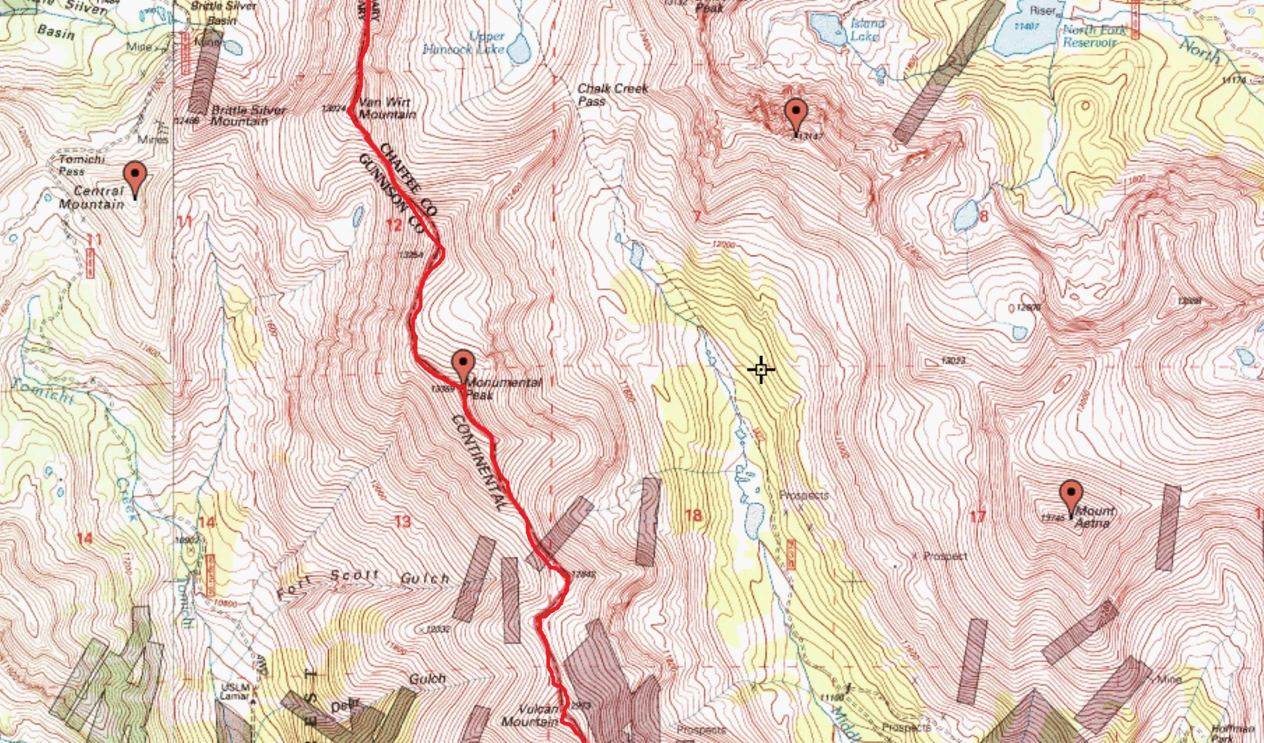
From Clover to Vulcan Mountain, the ridge is roughly ¾ mile. The entire way is perhaps Class 1+. It’s just a scree-patched tundra stroll. Both Clover and Vulcan Mountains aren’t ranked because of Bald Mountain and Monumental Peak respectively. While sitting on Vulcan, I could clearly see the ridge pushing up to the summit of this mid-13er. It was going to be some decent elevation gain. I would lose about 300’ give or take. But have to ascend about 740’. In terms of numbers, it wasn’t that bad. But of course, things always look worse when viewed from afar.
Along the 1.5-mile stretch, I saw the only two animals of the whole day (minus the grouse). I ended up scaring the hell out of a bull elk as I rounded a shoulder of talus. But more than that, there was another animal, small like a terrier that took off like a bullet. I watched it out of fascination because it moved so effortlessly and fluid across the talus. It wasn’t a wolf or coyote, of that, I am positive. If anything, I’d have to guess that it was probably a lynx or bobcat. I’m still in awe at how fast it moved.
The ridge leading up to Monumental Peak actually wasn’t bad as long as I wasn’t constantly watching the summit. Bill's page for it here on the .com is pretty good. The ridge was a talus masterpiece of great stability. In fact, all day, of all the talus I hopped (there really wasn’t much scree), like 95% of it was stable. And I only encountered maybe, two short sections of rock that I considered easy class-3, and they were super short at that. It was such a delight! Especially down here in the San Juan’s where if you even look at the rocks a little bit shifty, they’ll move.
Monumental Peak was a good summit. The north face has a huge scree slope that is entirely avoidable. The South Ridge winds to the summit via an easy talus march and continues to the north on an equally easy descent towards “Van Wit.” The views of Chalk Creek Pass, Sewanee Peak and Point 13,150 were wonderful. I lingered here for perhaps 15 minutes taking it all in. I could even still make out the radio towers over on Monarch Crest.
And thankfully, the weather cooperated all day. Only mild clouds meandered through the sky providing momentary relief from the sun. I never once worried about rain or wind. It was truly turning into an exceptionally great day.
The march over to “Van Wit” was quick and without notice. It’s a short distance, maybe a half mile. Looking over at the equally unranked “Van Wirt,” I thought, ‘Man, that’s going to take a while.’ The ridge dropped about 600’ in roughly .4 mile. But again, the talus was surprisingly stable.
About halfway up “Van Wirt,” I turned around to gauge my progress and was rewarded with what I thought was the best view of the entire ridge. From the north, “Van Wit” raised up like a massive parapet along the ridge. The North Face of Monumental was still visible just to the left and the north side of Chalk Creek Pass, Hancock Lake and the CT down below gave depth perspective. It really was amazing.
The traverse over to Hancock Peak was long. It looked farther than I was expecting. And with it being around 3:30 pm, I was really hoping for something shorter or at least, a social trail to follow. From “Van Wirt” to Hancock, the ridge was roughly 1.7 miles. But again, I was rewarded with a quicker than expected trip across the talus and blocks. I switched over to a playlist of old-school Industrial (think KMFDM, Sister Machine Gun, The Prodigy) so that may have had a part to play in making time go by fast. Even the steeper sections didn’t seem all that bad.
I replaced the register on Hancock Peak as the one that was there was in bad shape. Since Regina was going to walk up the road & meet me, I didn’t want to dawdle. I knew the north ridge off Hancock goes from Whiley’s trip but I REALLY didn’t want to add unnecessary additional mileage from walking down that 4x4 road from Hancock Pass since it meanders too much. So instead, I descended the north slope of Hancock down to the basin and dog-legged left and caught the road much further down.
I found a decent stream crossing the road and washed up. I only had to walk for maybe 15 minutes before I saw Regina and Kaiah chillin’ on the side under some trees. Of course, the dog went apeshit seeing me walk up. That made me smile!
This was a sweet ridge traverse and as easy as it gets. If you don’t care about unranked vs. ranked, 12ers or 13ers, blah, blah, blah, I highly recommend this route.

Looking east back at Monumental Peak from the summit of "Van Wit"

The upper choss pile/ridge on Monumental Peak. Somewhere around 13,200'

Selfie while on the CT/CDT. Clover Mountain is in the background above my head

Looking due east onto the lower Arkansas Valley and highway 50

Trail Markers...

An impressive looking Van Wirt Mountain. Unranked.